Trips, comments and notes for snowshoeing.
- Ratings.
- Program Trips
- Trips Further Afield
- Big Lake to Hot Chocolate.
- Sturgeon River to Almost Big Lake.
- Sturgeon River to Big Lake
- Chickakoo.
- Pembina River Provincial Park.
- Willmore-Edson Park.
- Further Afield but of Lower Interest
- Potential Areas (under review)
- Coyote Lake Natural Area.
- Burtonsville Island Natural Area.
- Hasse Lake Regional Park.
- Lily Lake Natural Area.
- Prefontaine Brock Lakes Natural Area.
- Matthews Crossing Natural Area.
- Wabamun Lake Provincial Park.
- Spruce Island Lake Natural Area.
- Bridge Lake Natural Area.
- Halfmoon Lake Natural Area.
- Opal Natural Area.
- Constable Chelsey Robinson Recreation Area.
- Prospectors’ Point Day Use Area.
- Bunchberry Meadows.
- Equipment:
- Resources.
— Top —
Program Trips
Victoria Park – Golfing with Big Feet
- Date (first done and most recent): 12-Jan-2016
- Starting Point: Victoria Park Parking Lot 12130 River Valley Rd, Edmonton
- Route:
- Victoria Park Oval parking lot.
- Head west of the Skate Shack and pick up the X-Ski trails.
- Cut north toward the escarpment to practice ascents, descents and traversing hills.
- Cautions or Notes: None, beginner.
Victoria Park – Hills Lite
- Date (first done and most recent): 19-Jan-2016
- Starting Point: Victoria Park Parking Lot 12130 River Valley Rd, Edmonton
- Route:
- Victoria Park Oval parking lot.
- Head west of the Skate Shack and pick up the X-Ski trails.
- Loop through Victoria Park Golf Course on the skate portion of the trail.
- Go east as far as the Glenora club and then take the North trail back.
- Based on the time, retrace our steps or short cut back to the skate shack.
- Cautions or Notes: None, beginner.
Mackinnon Ravine to Ravine Drive
- Date (first done and most recent): 27-Dec-2016
- Starting Point: Government House Park, 9938 Groat Road NW, Edmonton
- Route:
- West along MacKinnon Ravine from parking lot.
- Look for a trail on the North side past the stair case.
- Take trail up to Ravine Drive.
- Walk east along table-land until staircase, descend via staircase and return to parking lot.
- Cautions or Notes: could be slippery later in the season with melt, steep ascent in from the River Valley to table-land. Carry shoes down staircase.
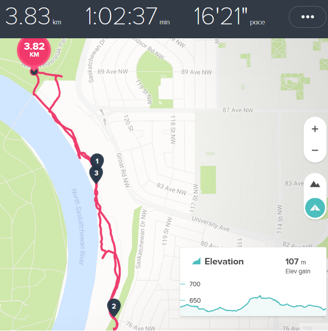
Kinsmen Park – Carry your Shoes
- Date (first done and most recent): 29-Dec-2016
- Starting Point: Victoria Park – East entrance
- Objective: a combination of snowshoeing and how to pack poles and shoes.
- Route:
- Walk east along bike trail to LRT Bridge, cross over to South side of the North Saskatchewan.
- Based on snow, snowshoe through Kinsmen park. Play in the back forest, practice small hill ascents, etc.
- Return via one of the bridges.
- Cautions or Notes: the focus is on packing snowshoes. The pathways are traveled enough to make this suitable for walking trip as well or in conjunction.
Hawrelak Park – Easy
- Date (first done and most recent): 30-Dec-2016
- Starting Point: Picnic Shelter #2 in Hawrelak Park.
- Objective: basic technique and skills, make use of the larger field for specific practice activities.
- Route:
- Snowshoe across the park to the entrance and then west toward the river.
- Pick up the river trail and return to the picnic shelter.
- Cautions or Notes:none.
Hawrelak Park – Ascent and Obstacles
- Date (first done and most recent): 30-Dec-2016
- Starting Point: Picnic Shelter #2 in Hawrelak Park.
- Objective: navigating through forested areas, narrow trails and steeper ascents.
- Route:
- Pick up one or more of the network of trails running parallel to the river and walk South (upstream).
- There are both wide groomed trails as well as narrow foot trodden trails.
- Turn around is reached by ascending to Grout Road; return can be via the same or other trails.
- Cautions or Notes: Due to erosion, some trails have hazards nearer the river bank with upwards of a 10M exposure. If done at night, tripping hazards in the narrow forested areas when stepping over log falls, etc..
Hawrelak Ascent and Obstacle Challenge – possible route
— Top —
Trips Further Afield
Big Lake to Hot Chocolate
- Date (first done and most recent): circa 2007 / 31Dec-2016
- Starting Point: 231 Street and Big Lake
- Objective: Walk the ~9KM from the put in back to St. Albert, explore the provincial park en route.
- Route:
- Car shuttle, taxi or drop off at 231 street and Big Lake.
- Walk to the lake and head east
- Note that the upper portion of the lake connects via a narrow channel approximately 1 KM from the put in.
- Lunch snack can be had en route.
- Cautions or Notes: best done after a good period of freeze. Normally the lake is very safe to walk on but springs, thaw periods, etc. can create open water.
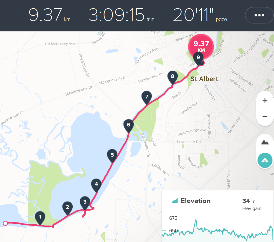
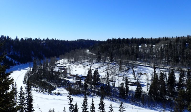
2016-12-31 – EBTC Big Lake hike
Sturgeon River to Almost Big Lake
- Description: The Sturgeon River’s head waters are the forests to the west of St. Albert. It snakes it way through the larger Yellow Head valley before eventually emptying into the North Saskatchewan near Fort Saskatchewan. This is one small portion roughly from Villneuve until Meadowview Drive. The next trip description describes the trek to Big Lake and then onto St. Albert.
- The route is along the river and generally there are lots of snowmobile and ATV tracks to follow.
- Because of springs and run off, care must be taken to avoid the occassional open water or ‘rotten ice’.
- Because of the ice concern, this trip is best done during the coldest months (e.g. January to the end of February).
- Despite the ice concerns, lots of wildlife tracks (and possibly a spotting or two) through this rural/semi-wild corridor near a major city.
- Links/Resources: City of St. Albert – Sturgeon River Water Shed.
- Location:
- Put-In approximately 54117 Range Rd 263, Sturgeon County, AB
- Take-out: 26109 Meadowview Drive, Sturgeon County, AB
- Activities: follow the river to the take out.
- Cautions or Notes: Caution and Ice safety awareness. It might be tempting to cut off some of the ox-bow turns of the river; I would recommend not as these are fenced and private property.
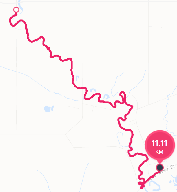
Route: Sturgeon River to Almost Big Lake
Chickakoo Lake Recreational Area
- Description: 480 acres of woodland and lakes, 11 kilometres of trails used for walking, mountain biking, horseback riding and cross country skiing. Trails are regularly groomed and tracks set regularly for cross country skiing in the winter months. Dogs are welcome on leash.
- Links/Resources: Parkland County.
- Location: 1228 Twp. Rd. 534, Sturgeon County.
- Activities: Multiple trails of varying difficulty, skiing, snowshoeing, etc.
- Cautions or Notes: None.
Pembina River Provincial Park
- Description: The park border a bow in the Pembina River on both the North and South sides directly north of the town of Entwhistle.
- Links/Resources: A highly popular provincial park.
- Location: ~90 km west of Edmonton just off of Highway 16.
- Activities: There are two many areas, on the hill over looking the river and the campground/river itself.
- The hill has about 3-5 km of easy trails with on with a descent that is slightly technical. The trails are well marked and accessible from two parking lots.
- The campground has roads, playgrounds and open spaces to trudge through as well as a trail that follows the river.
- Cautions or Notes: None.
- Trail map: Pembina River Provincial Park Map.
Pembina River Provincial Park
— Top —
Trips Further Afield but of Lower Interest
Hasse Lake Lake Regional Park
- Description: A 300 acre day use area that surrounds Hasse Lake. Ice fishing is allowed although I did not see any and most winter visitors seem to be dog walkers.
- Links/Resources: Managed by Sturgeon County.
- Location: South of highway 16 and west of secondary highway 770.
- Activities: There are 3km of trails and the park surrounds the lake. For youth groups (e.g. Scouting/Guiding, cadets, boys and girls) Hasse Lake is far enough away to give the sense of adventure without undue travel or hassle. For adults, a tramp and an explore about the lake is possible but there are more interesting locations closer to YEG.
- Cautions or Notes: Ice safety. .
- Trail map: None.
Jack Fish Lake Regional Park
- Description: A small day use area on Jack Fish Lake. In the summer it seems to be filled with cottages, anglers and recreational boats. In the winter, the few summer residents and the occasional ice fisher dot the scene.
- Links/Resources: Managed by Sturgeon County.
- Location: South of highway 16 and west of secondary highway 770.
- Activities: It was fun to walk around an island just off shore and chat with the ice fisher(wo)men in their little tent. Beyond that, one could make a day tramping around the lake and looking and beautiful and large homes. A fire and hot chocolate would round out the day. A long way to drive from Edmonton though when there are lakes closer.
- Cautions or Notes: Ice safety. .
- Trail map: None.
Willmore-Edson Regional Park
- Description: A small day use area on south of Edson that has about 12km of trails with some fun ups and downs across gulleys and down to the McCloud River. If this was 80 or so KM closer to Edmonton it would definitely be a place to explore in more detail. As nice as it is it is not worth the 2 hour drive from Edmonton.
- Links/Resources: Managed by the Town of Edson.
- Location: South of highway 16/Edson on Range Road 174.
- Activities: The park seems to be well used by the Edson’ites in the summer but we mostly had it to ourselves in February. There is a very well signed trail system which has some diversity in climbs, etc.
- Cautions or Notes: none
- Trail map:

— Top —
Equipment
Don’t you hate it, you have the perfect combination of equipment and then you can’t remember what you wore! The following is my attempt to take some notes under different conditions of equipment. Feel free to borrow and use but remember, I tend to run hot and so will often have less clothing except for on my hands (slight frost bite as a Scout in the 1970’s – ahhh the good old days when you could sustain real injuries).
Dress: What to Where on Different occasions
For each day trip, I will try to note the following either in the page or in the comments.
Day (heading): weather including temperature range, wind and light conditions.
- Head/Neck:
- Torso:
- Hands:
- Legs:
- Feet:
- Pack:
- Comments
2016-12-27: -8C to -4C light winds, sunny
- Head/Neck: light beanie or bare head to evacuate heat; initially a fleece headtube.
- Torso: long sleeve cycling jersey, fleece vest; cycling shell although this was quickly taken off.
- Hands: initially, neoprene cycling gloves and then full-finger summer cycling gloves.
- Legs: Shell pants with gaiters
- Feet: Hiking boots.
- Pack: Fanny pack
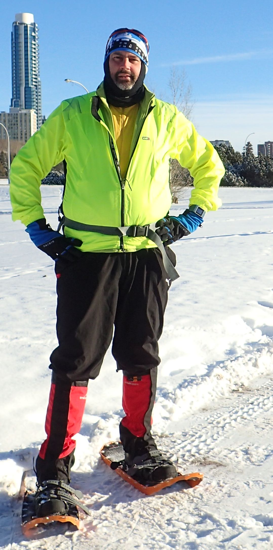
2016-12-27: -8C to -4C; too warm with shell and headtube.
2017-01-02: -25C to -19C, ice fog and the clearing, no wind.
- Head/Neck: Insulated cap, head tube.
- Torso: Winter insulated shell.
- Hands: Lobster mitts.
- Legs: Insulated snow pants
- Feet: Hiking boots.
- Pack: None.
- Comments: had to exchange neoprene gloves for lobster mitts. After ~20 minutes began to over heat so exposed head. Shell and fleece vest was adequate when temperature had warmed up (circa -17C to -20C).
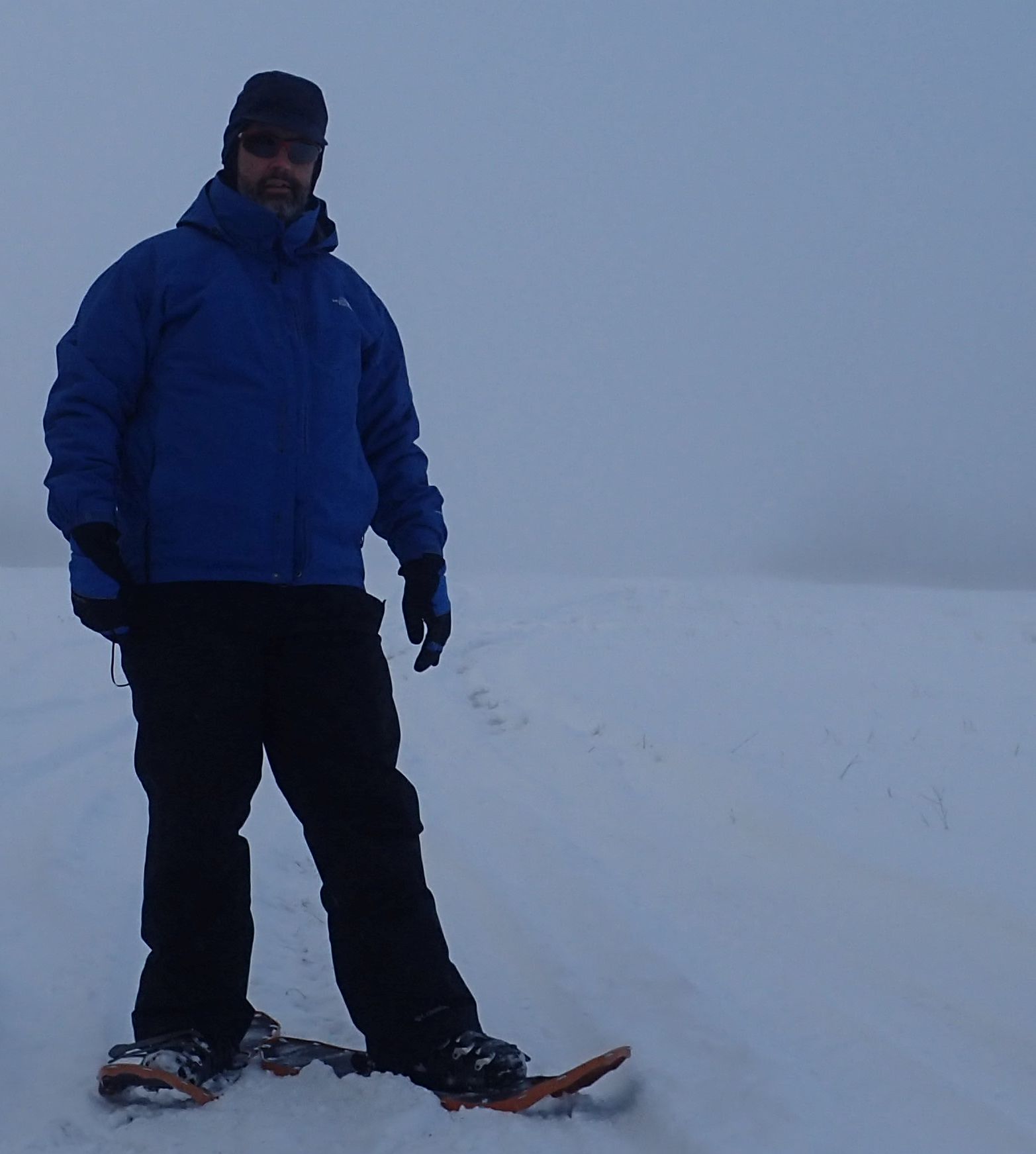
-25C to -20C attire. Overheated with head gear, ski pants worked well. Shell was too warm after -20C.https://www.albertaparks.ca/parks/central/pembina-river-pp/
